The Latest on Cuba and Hurricane Joaquin
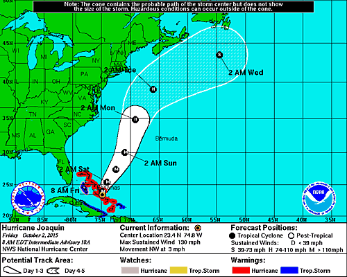
HAVANA TIMES — The powerful hurricane Joaquin continues its path slowly northwest in the Bahamas, currently moving at only 3 mph. It is expected to continue on a north track in the coming days. The storm packs maximum sustained winds of 130 mph.
While first seen as a major threat to parts of the mid-Atlantic coast of the USA, today it is being considered less of a threat.
In the case of Cuba, the outer bands of the storm may produce thunderstorms and some heavy rains from Camaguey to Guantanamo. An alert for coastal flooding is in effect for the north coast of central and eastern Cuba. Such flooding has already occurred in the municipalities of Niquero and Manzanillo in Granma province.
At 6:00 a.m. EST on Friday the center of the storm was located at about 200 miles southeast of Nassau in the northern Bahamas.