Cuba Puts Out Tropical Storm Warning
 HAVANA TIMES – Tropical Storm Nate caused widespread destruction and at least 23 deaths in Central America and is now en route to the tip of the Yucatan Peninsula, relatively close to far western Cuba.
Cuban Civil Defense Authorities have issued a tropical storm warning for Pinar del Rio and a tropical storm watch for the Isle of Youth. These were the only two areas of the country that were not affected by hurricane Irma last month. Heavy rains, sea surge and flooding are the biggest danger.
The storm which developed very quickly in the western Caribbean is gaining in intensity and is projected on a path that will take it near New Orleans in the United States; the widespread rains carried by Nate have led to numerous tropical storm warnings to be posted.
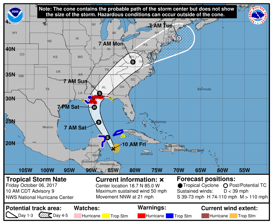
At 10 AM EDT, Nate now has maximum sustained winds of 50 mph (85km/h) and is moving swiftly north-northwest at 21 mph(35 km/h).
In Nicaragua there are at least 11 deaths and 7 persons missing and electricity is still out in numerous municipalities.
The following is the latest Public Advisory put out by the National Hurricane Center in Miami, the leading authority on such events.
Tropical Storm Nate Advisory
National Hurricane Center Miami FL
1000 AM CDT Fri Oct 06 2017
…NATE STRENGTHENING OVER THE NORTHWESTERN CARIBBEAN SEA…
…HURRICANE AND STORM SURGE WARNINGS ISSUED FOR THE NORTHERN GULF
COAST…
SUMMARY OF 1000 AM CDT…1500 UTC…INFORMATION
———————————————–
LOCATION…18.7N 85.0W
ABOUT 175 MI…280 KM SE OF COZUMEL MEXICO
ABOUT 165 MI…260 KM NNE OF ISLA GUANAJA HONDURAS
MAXIMUM SUSTAINED WINDS…50 MPH…85 KM/H
PRESENT MOVEMENT…NNW OR 340 DEGREES AT 21 MPH…33 KM/H
MINIMUM CENTRAL PRESSURE…996 MB…29.42 INCHES
WATCHES AND WARNINGS
——————–
CHANGES WITH THIS ADVISORY:
A Hurricane Warning is now in effect from Grand Isle Louisiana
to the Alabama/Florida border.
A Storm Surge Warning is now in effect from Morgan City Louisiana to
the Alabama/Florida border, and for the northern and western shores
of Lake Pontchartrain.
A Tropical Storm Warning is now in effect for metropolitan New
Orleans, Lake Pontchartrain and Lake Maurepas, and from west of
Grand Isle to Morgan City Louisiana.
A Hurricane Watch is now in effect east of the Alabama/Florida
border to the Okaloosa/Walton County Line.
A Storm Surge Watch is now in effect east of the Alabama/Florida
border to Indian Pass, Florida.
A Tropical Storm Watch is now in effect east of the Okaloosa/Walton
County Line to Indian Pass, Florida.
The Government of Cuba has issued a Tropical Storm Warning for the
Provence of Pinar del Rio and a Tropical Storm Watch for the
Provence of the Isle of Youth.
The Meteorological Service of Honduras has discontinued the
Tropical Storm Warning for the coast of Honduras.
SUMMARY OF WATCHES AND WARNINGS IN EFFECT:
A Hurricane Warning is in effect for…
* Grand Isle Louisiana to the Alabama/Florida border
A Storm Surge Warning is in effect for…
* Morgan City Louisiana to the Alabama/Florida border
* Northern and western shores of Lake Pontchartrain
A Tropical Storm Warning is in effect for…
* Punta Herrero to Rio Lagartos Mexico
* Pinar del Rio
* Metropolitan New Orleans
* Lake Pontchartrain and Lake Maurepas
* West of Grand Isle to Morgan City Louisiana
A Hurricane Watch is in effect for…
* Punta Herrero to Rio Lagartos Mexico
* Metropolitan New Orleans
* Lake Pontchartrain and Lake Maurepas
* East of the Alabama/Florida border to the Okaloosa/Walton County
Line
* West of Grand Isle to Morgan City Louisiana
A Storm Surge Watch is in effect for…
* East of the Alabama/Florida border to Indian Pass Florida
A Tropical Storm Watch is in effect for…
* East of the Okaloosa/Walton County Line to Indian Pass Florida
* West of Morgan City to Intracoastal City Louisiana
* Isle of Youth
A Hurricane Warning means that hurricane conditions are expected
somewhere within the warning area. A warning is typically issued
36 hours before the anticipated first occurrence of
tropical-storm-force winds, conditions that make outside
preparations difficult or dangerous. Preparations to protect life
and property should be rushed to completion.
A Tropical Storm Warning means that tropical storm conditions are
expected somewhere within the warning area.
A Storm Surge Watch means there is a possibility of life-
threatening inundation, from rising water moving inland from the
coastline, in the indicated locations during the next 48 hours.
For a depiction of areas at risk, please see the National Weather
Service Storm Surge Watch/Warning Graphic, available at
hurricanes.gov.
A Hurricane Watch means that hurricane conditions are possible
within the watch area.
A Tropical Storm Watch means that tropical storm conditions are
possible within the watch area, generally within 48 hours.
Interests elsewhere in western Cuba, the Yucatan Peninsula, and the
northern coast of the Gulf of Mexico should monitor the progress of
Nate.
For storm information specific to your area in the United
States, including possible inland watches and warnings, please
monitor products issued by your local National Weather Service
forecast office. For storm information specific to your area outside
the United States, please monitor products issued by your national
meteorological service.
DISCUSSION AND 48-HOUR OUTLOOK
——————————
At 1000 AM CDT (1500 UTC), the center of Tropical Storm Nate was
located near latitude 18.7 North, longitude 85.0 West. Nate is
moving toward the north-northwest near 21 mph (33 km/h) and this
motion is expected to continue through Saturday, with a turn toward
the north and northeast expected Saturday night and Sunday. On the
forecast track, the center of Nate will move across the
northwestern Caribbean Sea today, and move near or over the
northeastern coast of the Yucatan peninsula this evening. Nate will
then move into the southern Gulf of Mexico tonight, approach the
northern Gulf coast Saturday, and then move near or over the
northern Gulf coast Saturday night or Sunday.
Reports from Air Force Reserve and NOAA Hurricane Hunter aircraft
indicate that maximum sustained winds are now near 50 mph (85 km/h)
with higher gusts. Additional strengthening is forecast during the
next couple of days, and Nate is expected to become a hurricane by
the time it reaches the northern Gulf of Mexico.
Tropical-storm-force winds extend outward up to 115 miles (185 km)
mainly to the east of the center.
The minimum central pressure estimated from the Hurricane Hunter
data is 996 mb (29.42 inches).
HAZARDS AFFECTING LAND
———————-
RAINFALL: Nate is expected to produce the following rain
accumulations through this weekend:
Southern Honduras and western Nicaragua: 6-10 inches, max 15 inches
Eastern El Salvador and northern to central Honduras: 3 to 5 inches,
max 8 inches
Eastern Yucatan and western Cuba: 2 to 4 inches, max 8 inches
Eastern Belize and the Cayman Islands: 1 to 3 inches
U.S. Central Gulf Coast states, eastern Tennessee Valley and
southern Appalachians: 3 to 6 inches, max 12 inches
Heavy rainfall will occur over a wide area, including locations well
away from the center along the Pacific coast of Central America.
Rainfall across all of these areas may produce life-threatening
flash floods and mudslides.
WIND: Hurricane conditions are possible within the hurricane watch
area in Mexico by tonight, with tropical storm conditions expected
by this evening. Tropical storm conditions are expected in the
warning area in Cuba by tonight, and are possible in the watch area
in Cuba tonight.
Along the northern Gulf Coast, hurricane conditions are expected in
the hurricane warning area Saturday night, with tropical storm
conditions expected by late Saturday. Tropical storm conditions are
expected in the tropical storm warning area by Saturday night.
Hurricane conditions are possible in the hurricane watch area
Saturday night, and tropical storm conditions are possible in the
tropical storm watch area Saturday night and Sunday.
STORM SURGE: In the United States, The combination of a dangerous
storm surge and the tide will cause normally dry areas near the
coast to be flooded by rising waters moving inland from the
shoreline. The water is expected to reach the following heights
above ground if the peak surge occurs at the time of high tide…
Morgan City, Louisiana to the Alabama/Florida border…4 to 7 ft
Alabama/Florida border to Indian Pass, Florida…2 to 4 ft
The deepest water will occur along the immediate coast near and to
the east of the landfall location, where the surge will be
accompanied by large and destructive waves. Surge-related
flooding depends on the relative timing of the surge and the tidal
cycle, and can vary greatly over short distances. For information
specific to your area, please see products issued by your local
National Weather Service forecast office.
In Mexico, a storm surge will raise water levels by as much as 1
to 3 feet above normal tide levels along the immediate coast in
areas of onshore winds on the Yucatan Peninsula and the adjacent
islands. Near the coast, the surge will be accompanied by large and
destructive waves.
SURF: Swells generated by Nate will affect land areas around the
northwestern Caribbean during the next day or so. These swells are
likely to cause life-threatening surf and rip current conditions.
Please consult products from your local weather office.