Tropical System Heads for Nicaraguan Caribbean Coast
HAVANA TIMES – A newly formed Tropical Depression, expected to intensify to a Tropical Storm, is slowly churning towards a possible landing on the northeastern coast of Nicaragua by some time Thursday evening.
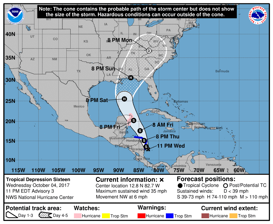
The weather system currently has 35 mph maximum sustained winds and is expected to bring considerable rainfall in Central America all the way from Panama to Honduras. It is moving slowly at only 6 mph which increases the possibility of intense local rains and flooding, warns the National Hurricane Center (NHC) in Miami.
This year’s Atlantic hurricane season, which runs from June 1 to November 30th, has been extremely deadly and damaging in the Caribbean Islands and parts of the United States.
The following is the latest public advisory from the NHC issued at 11:00 p.m. EDT on October 4.
BULLETIN
Tropical Depression Sixteen Advisory Number 3
…DEPRESSION HEADING TOWARD THE NICARAGUA COAST…
…FLOODING RAINS EXPECTED OVER PORTIONS OF CENTRAL AMERICA…
SUMMARY OF 1100 PM EDT…0300 UTC…INFORMATION
———————————————–
LOCATION…12.8N 82.7W
ABOUT 70 MI…115 KM WNW OF SAN ANDRES ISLAND
ABOUT 95 MI…155 KM SSE OF PUERTO CABEZAS NICARAGUA
MAXIMUM SUSTAINED WINDS…35 MPH…55 KM/H
PRESENT MOVEMENT…NW OR 310 DEGREES AT 6 MPH…9 KM/H
MINIMUM CENTRAL PRESSURE…1004 MB…29.65 INCHES
WATCHES AND WARNINGS
——————–
SUMMARY OF WATCHES AND WARNINGS IN EFFECT:
A Tropical Storm Warning is in effect for…
* Sandy Bay Sirpi Nicaragua to Punta Castilla Honduras
A Hurricane Watch is in effect for…
* Punta Herrero to Cabo Catoche Mexico
A Tropical Storm Warning means that tropical storm conditions are
expected somewhere within the warning area, in this case within
12-24 hours.
A Hurricane Watch means that hurricane conditions are possible
within the watch area. A watch is typically issued 48 hours
before the anticipated first occurrence of tropical-storm-force
winds, conditions that make outside preparations difficult or
dangerous.
Interests elsewhere in Honduras, the Bay Islands, western Cuba and
the Yucatan Peninsula should monitor the progress of the
depression.
For storm information specific to your area, please monitor
products issued by your national meteorological service.
DISCUSSION AND 48-HOUR OUTLOOK
——————————
At 1100 PM EDT (0300 UTC), the center of Tropical Depression Sixteen
was located near latitude 12.8 North, longitude 82.7 West. The
depression is moving toward the northwest near 6 mph (9 km/h), and
this motion is expected to continue through early Thursday. A
north-northwestward motion at a faster forward speed is forecast to
begin on Thursday and continue through late Friday. On the
forecast track, the center of the depression should move across
northeastern Nicaragua and eastern Honduras on Thursday and then
over the northwestern Caribbean Sea Thursday night and Friday. The
center is expected to approach the coast of the Yucatan peninsula
late Friday.
Maximum sustained winds are near 35 mph (55 km/h) with higher gusts.
The depression is forecast to strengthen to a tropical storm before
it moves inland over northeastern Nicaragua tomorrow. Additional
strengthening is likely over the northwestern Caribbean Sea
Thursday night and Friday.
The estimated minimum central pressure is 1004 mb (29.65 inches).
HAZARDS AFFECTING LAND
———————-
RAINFALL: The depression is expected to produce the following rain
accumulations through Friday night:
Nicaragua…15 to 20 inches, isolated 30 inches
Costa Rica and Panama…5 to 10 inches, isolated 20 inches
Honduras…2 to 5 inches, isolated 8 inches
Heavy rainfall will occur over a wide area, including locations well
away from the center along the Pacific coast of Central America.
This rainfall could cause life-threatening flash floods and
mudslides.
WIND: Tropical storm conditions are expected to start in the
warning area in Nicaragua early on Thursday, and spread into
Honduras late Thursday. Tropical storm and hurricane conditions are
possible within the watch area in Mexico beginning late Friday.
SURF: Swells generated by the cyclone are affecting portions of
the coast of Nicaragua, and will begin to affect other land areas
around the northwestern Caribbean later this week. These swells are
likely to cause life-threatening surf and rip current conditions.
Please consult products from your local weather office.